Buffalo Mountain
One way to get the most out of life is to look upon it as an adventure.
~William Feather
I've been waiting to tell you about this hike. Glory B! This, no doubt, will be one of the highlights of our trip. Not because it was any prettier, but because of the physical intensity of it. Cliff and I decided, sort of spontaneously, to hike up Buffalo Mountain. We had read that there were old cabin ruins on the trail before clearing the tree line. That's what I wanted to see. We, also, learned that the hike could be broken into 3 sections. The forest up to the cabin, the boulder field, and the summit section. And at the summit, you could see mountain goats. Round-trip length, if you went to the summit, was 5.5 miles. Well, I had no intention of going to the top. Knowing the distance would be much shorter made the decision to hike much easier.
We drove to the trailhead, gathered our backpacks and headed up the trail. The trailhead sign said there could be moose in the area, so I was on the look out. Never saw a moose. The alpine forest was so pretty and peaceful to hike through. The Colorado pines towered above us blocking most of the sunlight. In the beginning, the trail was mostly dirt....well worn and only a slight incline. The farther into the woods we got, the trail became steeper and was dotted with roots and rocks. And in time, we came to the ruins of an old cabin. I thought I had read there were a couple, but we only saw the one. And when they said ruins, that's what they meant.
After arriving at the cabin, and talking to a few people that were on their way down, we decided that the boulder field wasn't that much farther and since I still felt pretty good, it would be a shame to go that far and not go to the boulder field.
Well y'all, the trail took a turn for the steep and rocky. Steep, rocky and rooty! At some point we were actually climbing up and over rocks. I had to stop many, many times to catch my breath and let my heart rate return to normal. The combination of thin air and steep terrain is why Whitney has not been able to get me on one of her 14'ers. My lungs just doesn't work like theirs. Ha!
Somewhere between the cabin and the boulder field, we realized that we were unprepared for that kind of hike. I had one bottle of water and Cliff had a half a bottle of Gatorade. I tried to conserve my water as much as possible. When we had made it about half way from the cabin to the boulder field, I needed fuel. All I had in my backpack was a peppermint. Cliff had an airplane size pack of cashews and a gel pack. I ate the peppermint and we shared the nuts and gel. I'm telling you that a peanut butter and jelly sandwich would have come in mighty handy at this point. But we ate what we had and journeyed on.
Cliff was not having any problems, but the closer to the boulder field we got, I began to feel nauseated and got a headache. I felt like if I breathed too deeply that I was going to throw up. I felt dizzy when we stopped to rest....which was often. My heartrate was way up and breathing was difficult. During rest stops, it didn't take long to recover, but then I could only go short distances before having to stop again. Now, you may be asking why in the world would I continue to put myself through that. Several reasons, actually. This was an adventure of epic proportions! To be able to say that I climbed a mountain, the views...THE VIEWS....and to be able to share being outdoors and hiking with Cliff was enough.
Finally, we made it to the boulder field. I was a mess, but the views that surrounded us were so magnificent. Once my breathing and heart rate returned to normal, I was able to soak them up. Cliff explored a little bit of the boulder field and I'm sure he wanted to go to the top, but I was done. After taking lots of pictures and resting some, we headed back down. Rain was in the forecast for the afternoon and we didn't want to be on the mountain, if it started lightening.
On the way down, my breathing and heartrate were not a problem. We were gaining oxygen and I felt invigorated....except....my legs were now pretty much shot. My thighs quivered almost constantly and my toes were pushed to the front of my shoes causing lots of discomfort. There were times that my feet slid on the steep gravel/dirt areas where there were no rocks or roots to brace my foot against. I slipped and fell on my buttocks, once. Scared the bejeebies out of me. Even so, we made record time coming down.
Buffalo Cabin Trail Hike Stats (to boulder field only):
Elevation at the start: 9784.9 feet
Elevation at the end: 11,390 feet
Elevation gain of: 1377.9 feet
Total miles hiked: 3.75
Time to ascend: 2:45 hours
Time to descend: 1:30 hours
Total hours hiked: 4:15 hours
Starvation rate: Unmeasurable
Scenery: Out of this world beautiful!
Would I do this hike again? NO! Well, maybe if I were to train for these kind of conditions....steep hiking and climbing. Give me a year and then ask me again.
Starting to get steep.
The cabin ruins.
Literally, only a few logs left.
Getting steeper.
I took a sip from this stream. Not recommended, but I wanted to see what true mountain water tasted like. It was tasty and very cold.
Views between cabin and boulder field.
Yes, we climbed this.
Not far from the boulder field, now.
Almost above the tree line, now.
We made it. Views from the boulder field.
The cairn marking the way through the boulder field to the summit.
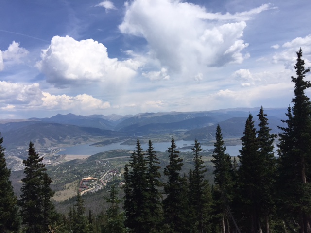
Lake Dillon as seen from Buffalo Mountain.
Cliff surveying the boulder field....
This would be the climb up through the boulder field. But, that is not the top. It's a false summit. The true summit is over the top another mile.
A close-up of the area we climbed to...above the tree line to the boulder field.
We climbed just above the tree line. Somewhere just right of the center of this picture.
This quote sums up my feelings for the day. I will look back on this as a great adventure. As hard as it was, I'm so glad I did it.
I'll look back on this and smile because it was LIFE and I decided to live it.
~Author unknown
Laurie